
Explore a forest trail in Helensburgh, thanks to Geoff Whale, author of Northern Illawarra Beachwalks (bcw.grwpub.info)
FAST FACTS
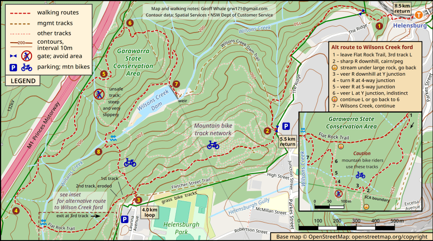
Distance 4km to 8.5km, climb 100 to 200m
Difficulty Moderate, requires concentration
Summary Interesting and varied forest walk, using old and new (often bike) tracks.
Hazards Bike riders; slippery after rain.
Transport Helensburgh station, or park as shown at 2 or 3 for shorter walks.
From the station take the steep steps and turn right at [1] to continue behind houses, past the gate and into the park. Follow the track for 1.4km, climbing steadily. Swing left past a short link track and join the wide fire trail. Just before the gate there’s a bush track on the right, running uphill parallel to the road [2]. Continue ascending until you meet a wider, dry ridgetop track. Ignore the many side paths; after 0.8km you reach a major junction [3]. Continue straight ahead.
Flat Rock Trail is signposted, but is badly eroded in places. A more interesting route to Wilsons Creek passes through a network of unauthorised bike tracks (though in good condition and excellent walking); locate the third exit and follow the inset map. You’ll need to concentrate on navigating 1 to 7.
Either way you’ll reach the ford, where Wilsons Creek flows mostly in rock crevices. Cross carefully and walk up the hill. Try to ignore the M1 motorway noise, now prominent. Before a left turn uphill, look for a track [4] on the right. It leads into casuarina forest; the mostly rocky path can be slippery as it crosses three minor creeks in 300m.
After crossing another creek that flows under rocks, you reach a junction [5] where the canopy opens out. Continue straight uphill; the route downhill is quite dangerous as it’s steep, treacherous clay. The next junction is with the wide Garawarra Ridge Trail [6]. Turn right, downhill. When you reach the powerline, look for a path on the left. This passes through wonderful, dry open forested slopes, emerging eventually at Wilsons Creek Dam [7].
Have a rest, explore the dam, weir and creek downstream if you like, then return to the northern end of the wall. Now turn left along the level path above the dam (regrettably without views). Pass the bottom end of the unsafe link track, veer left down to the creek crossing [8]. Again be careful after recent rains; in dry conditions step across.
The uphill return leg joins part of an extensive mountain bike network. Ignore side tracks and keep alert for riders. The 4km circuit emerges at the ridgetop; then retrace.


