

Thanks to Geoff Whale for sharing this extract from his new guide, Northern Illawarra Beachwalks. Download a PDF of this page from our June print edition
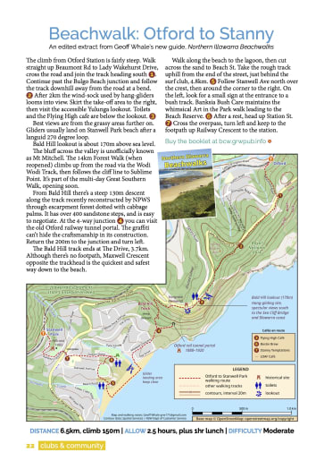
- Distance 6.5km, climb 150m
- Allow 2.5 hours, plus 1hr lunch
- Difficulty Moderate
- Summary This richly varied walk combines clifftop habitat, magnificent views, escarpment forest, beach and back-street routes, with a bit of history thrown in.
- Transport Sydney trains. Adjust your timing to get to the station for the return service.
The climb from Otford station is fairly steep. Walk straight up Beaumont Rd to Lady Wakehurst Drive, cross the road and join the track heading south (north is the Coast Walk). Continue past the Bulgo Beach junction and follow the track downhill away from the road at a bend.
After 2.0km the wind-sock used by hang-gliders looms into view. Skirt the take-off area to the right, then visit the accessible Yulunga lookout. Toilets and the Flying High cafe are underneath the lookout.
Best views are from the grassy areas further on, but keep clear of any flight preparations. Gliders usually land on Stanwell Park beach after a languid 270 degree loop.
Bald Hill lookout is about 170m above sea level (not the 300m claimed by some sources). That’s still enough to see most of the Illawarra coast on a clear day, including the classic S-shaped sweep of the Sea Cliff Bridge.
The bluff across the valley is unofficially known as Mt Mitchell. The 14km Forest Walk (when reopened) climbs up from the road via the Wodi Wodi Track, and then follows the cliff line to Sublime Point. It’s part of the multi-day Great Southern Walk, soon open.
From Bald Hill there’s a steep 130m descent along the track recently reconstructed by NPWS through classic escarpment forest dotted with cabbage palms. It has over 400 sandstone steps, and is easy to negotiate.
At the 4-way junction you can visit the old Otford railway tunnel portal, in use from 1888 to 1920 when the rail line was lower and aligned more easterly. The graffiti can’t hide the evident craftmanship in its construction. Return the 200m to the junction and turn left.
The Bald Hill track ends at The Drive, 3.7km. Although there’s no footpath, Maxwell Crescent opposite the trackhead is the quickest and safest way down to the beach.
Unless you’re in a hurry, walk along the beach to the lagoon, or at least as far as the surf club, then cut across the sand to Beach Street. Take the rough track uphill from the end of the street, just behind the club, 4.8km. Follow Stanwell Avenue northward over the crest, then around the corner to the right. Keep your eye on the left for a small sign at the entrance to a rough bush track.
Banksia Bush Care maintain the whimsical Art in the Park walk that leads down to the Beach Reserve. It features “nests” with porcelain eggs painted in the style of famous artists, as well as informative signs identifying tree species. 5.3km.
You can buy lunch or a coffee at one of the cafés listed on the map. After a rest head up Station Street. Cross the overpass, turn left and keep to the footpath as Railway Crescent curves around to the station.
Geoff Whale recently released Northern Illawarra Beachwalks, available from local outlets or online at bcw.grwpub.info